|
BHUTAN
|
|
Places
Of Interest
|
| WESTERN
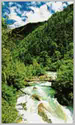
BHUTAN Western Bhutan is comprised of Paro, Thimphu and Punakha, Wangdue Phodrang and Phobjika valleys separated by high passes or "La" - Cheili La (3900m / 12,795ft.), Dochu La (3,050m / 10,007ft.) and Pele La (3,500m / 11483ft.). Western Bhutan is known for its stunning scenery with rice paddies cascading down magnificent mountains, the pristine rivers that flow through the main towns of Paro, Thimphu and Punakha, and unique two-story houses with brightly painted window designs. Below are described the main areas of Western Bhutan. |
 |
| PARO
VALLEY
Altitude: 2,250m / 7,382ft. A trip to Bhutan normally begins and ends at Paro ..... and there can be few more charming valleys in the kingdom. As you disembark your Druk aircraft and take your first breath of Bhutanese air, you will be struck by the clean air and peaceful atmosphere. National Museum. The museum's collection includes ancient Bhutanese arts and artifacts, weapons and stamps, birds and animals, and an incredible collection of silver tea ware. This is typical of the eclectic beauty of Bhutan - its prized objects bear little relation to each other but as a whole stand together as a history of one of the world's most pristine people. |
|
 |
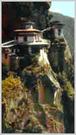
Taksang Monastery It is said that Guru Rinpoche (Precious Master), the father of the Bhutanese sect of Mahayana Buddhism, arrived in Paro Valley more than a millennium ago on the back of a legendary tigress. He meditated for three months in a cave where a monastery was later built and called Taktsang Lhakang or Tiger's Nest Visitors to Paro can take a closer look |
| at the monastery by ascending either on foot or by pony for about three hours to Tiger's Nest. Walkers can enjoy a rest at the Taktsang Teahouse situated at a wonderful vantage point overlooking the monastery. On clear days you can get a clear view of mount Chomolhari the sacred peak of Bhutan. | |
| THIMPHU
VALLEY Altitude: 2,350m / 7,710ft. Thimphu is a small, charming capital city sandwiched in the heart of the Himalayas. It sits in its own valley fanning out from the river. The skyline hardly changes as new buildings are all constructed under zoning regulations. Thimphu's development is strictly monitored and buildings cannot exceed a certain height, nor can they be designed in anything but the traditional Bhutanese style. In fact, Thimphu's first and only traffic light was enshrined in a chorten ! (a small Buddhist temple). Not being suitable to the nature of Thimphu, the traffic light was removed on the King's orders. |
|
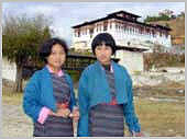
Only a sprinkling of cars are found along the main street and the capital's population is not immediately visible. But, if you look inside the bank or the shop, you will find Thimphu's people and Bhutan's heart. Dressed in gho or kira (a wrap-around robe), Thimphu people go about their work methodically, quietly bringing their nation through the growing pains of development and into its own definition of the modern world. |
 |
| Simtokha
Dzong, six kms from the city
limits,
is the kingdoms
oldest dzong which is now used as the Dzongka language school of Bhutan.
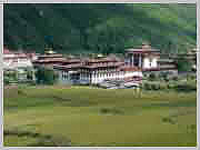
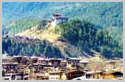
Bhutan's most stately and arguably most impressive building is Tashichhodzong,
on the banks of the Wangchu (Thimphu River). The home of the National
Assembly and the summer residence of the capital's venerated monastic
community, Tashicchodzong is a palatial building overlooking the river
on the South side and the city of Thimphu from the North. While foreign
visitors are only allowed to enter Tashicchodzong during the annual
festival, its presence and its exterior and grounds provide a delightful
spectacle. The dzong is the impressive result of a redesign of the
original medieval structure sanctioned by the Third King, HM Jigme
Dorje Wangchuck, when he moved Bhutan's permanent capital to Thimphu. One of the most enjoyable ways of passing time in Thimphu is wandering through the town. Full of wonderful restaurants and delighful shops stocked with items from all over Bhutan. Hand woven textiles, woodcarving, tailor made clothing, jewelry. Thimphu's weekend market is another chance to watch the way life in the kingdom. Here, every weekend, Thimphu's residents break from whatever it is that they are doing to stock vegetables, a copy of Kuensel (the weekly newspaper) and to exchange the week's gossip. For visitors who can't share in the gossip, a wander through the stalls reveals mountains of bright red chilies, eggplants and okra, asparagus in season and rice of many types. Traditional Bhutanese masks, incense, hand made knives, jewelery are also sold here. It's an incredible experience for the visitor. Another of Bhutan's loveliest exports is its wide and diverse collection of stamps. These are best seen in commemorative books at Thimphu's central post office. Other places of interest in Thimphu include the traditional painting school where the age-old styles of Bhutanese painting, including thangka painting, are taught and the Memorial Chorten build in memory of His Majesty, the Third King of Bhutan. The National Library houses a vast collection of books and research documents of Buddhist studies. |
|
|
PUNAKHA
VALLEY |
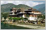
From the pass the road curls its way down into the relative lowlands of the Punakha Valley. Before Thimphu was made the permanent capital of Bhutan, Punakha was the Winter Capital because of its more temperate climate. The Je Khenpo (leader of Bhutan's religious order) and his council of monks still come to pass the Winter months here. Punakha Dzong was strategically built at the confluence of the Pho Chu (male) and Mo Chu (female) rivers by the first Shabdrung of Bhutan, Ngawang Namgyel in 1637. It has been damaged by four fires and an earthquake in 1897 and has been devastated by flood water coming from the great northern glaciers. The Dzong has now been fully restored to its original splendor. |
|
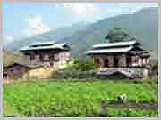
| WANGDUE
PHODRANG Altitude: 1,310m / 4,300ft. Wangdue Phodrang is the last westerm town on the highway before central Bhutan. Wangdue Phodrang (or Wangdue) is a typical small Bhutanese town. It has a bustling market with well stocked shops and a pretty view of the valley and dzong. |
 |
 |
PHOBJIKA
VALLEY & GANGTEY GOMPA Altitude: 2,900m / 9,510ft. A few hours' drive from Wangdue Phodrang is Phobjika valley. Here also is Gangtey Gompa, a monastery dating back to the 17th century. This short journey south from the main East-West artery is well worth the detour for the dramatic change of scenery. The monastery is inhabited only in summer months. Spotting black-necked cranes in the meadows of the valley floor is an ornithologist's dream come true. These rare birds migrate from the high plains of the Tibetan plateau in Winter to the milder climate of Phobjika. |
|
PHUENTSHOLING Altitude: 300m / 985ft. Popularly known as the 'Gateway to Bhutan', Phuentsholing is a vibrant town located adjacent to the Indian border town of Jalpaiguri, a district of the Indian state of West Bengal. The town is a bustling commercial centre providing a glimse of Indian merchants and Bhutanese dressed in traditional khos and kiras. The climate of Phuentsholing contrasts greatly with the higher land of Bhutan. It is tropical, hot and humid during the summer, and warm and pleasant in the winter. It is located 180 km from Thimphu and is about a six hours drive. Phuentsholing is the only other entry/exit point to Bhutan other than the airport at Paro. The closest Indian domestic airport is at Bagdogra, about 160 km from the Bhutanese boarder, which is connected by daily flights to Delhi and Calcutta. |
| CENTRAL
BHUTAN The Black Mountains separate Western Bhutan from Central Bhutan. This region includes Trongsa and the rich broad valleys of Bumthang including Chumey, Choekar, Tang and Ura valleys. The passes crossed are Yotang La (3425m, 11,237ft.) and Thrumsing La (3780m, 12,402ft.). Central Bhutan is known for its buckwheat and apple production, its sturdy stone houses, and its plethora of monasteries. Its the ideal place for walking due to its broad valleys and sloping mountains. The beauty of the Bumthang valley is legendary. Below are described the main areas of Central Bhutan. |

|
| TRONGSA
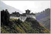
Altitude: 2,200m / 7,215ft. Crossing the Black Mountains which separate western and central Bhutan, you'll enter a part of the country which until the l970's was only reached by mule and foot trails. The mountain road passes through deciduous forests and at the second pass, Pele La, the entire area is blanketed by high altitude dwarf bamboo. About five miles from Trongsa, the road winds around a cliff to a viewpoint looking down onto the settlement of Trongsa. The view is one of the most beautiful sights in all Bhutan and one from which you may remember for a long time. Sloping down the contours of a ridge stands the many-leveled Trongsa Dzong, built in 1648. It takes at least another 40 minutes from the look-out before you arrive in Trongsa proper. The dzong acts as a defensive fortress, and its bright golden yellow roof occupies most of the view from Trongsa. Trongsa is the ancestral home of the Royal Family. The Crown Prince of Bhutan traditionally becomes "Penlop" (Governor) of Trongsa before being crowned King. Trongsa Dzong was built in 1648 and has been the traditional home of all four kings of Bhutan prior to their ascending the throne. Trongsa's location in the geographic center of the kingdom has enabled a "Penlop" (Governor) to effectively control the entire East and West of the country from there. Ta Dzong, the watch tower, which once guarded the Dzong from internal rebellion, stands impressively above the Dzong and provides visitor with some insight into the historical significance of Trongsa in Bhutan's history. |
| BUMTHANG
VALLEYS Continuing past Trongsa you'll travel over two spectacular passes into the Bumthang Valley, often compared to Switzerland. The terrain changes quickly from rhododendron forests to conifers. The first valley, Chumey (2,700m / 8,860ft.) is a wide fertile valley where wheat, barley, potatoes and buckwheat are cultivated. It is also known for it's famous wool weaving called "Bumthang Yathra". Continuing we enter the Bumthang Valley consisting of the Choekar (West), Jakar and Tang (East) Valleys. With the main town of Jakar serving as its capital. |
|
 |
JAKAR Altitude: 2,800m / 9,185ft. The hills around Jakar are filled with monasteries dedicated to Guru Rinpoche (Padmasambhava) who is said to have cured an ailing ruler and introduced Buddhism to the valley. Bumthang is also home to one of the great Buddhist teachers, Pema Lingpa, to whose descendants the present dynasty traces its origins. Pema Lingpa was a blacksmith who was led by mystic forces to discover spiritual treasures (termas) placed by Guru Rinpoche at the bottom of Mebartsho |
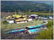
| or Flaming Lake. Not knowing how to impart the knowledge contained in the treasures he hid until one day the Dakinis, or female heavenly spirits, showed him the power of preaching. Legend explains that as he spoke, flowers dropped from the sky and vanished into rays of light. Jambay Lhakang Drub Monastery is host to one of the most spectacular festivals in October each year when on one evening of the festival, the monastery is lights up with a fire dance to bless infertile women with children. No where else in Bhutan will you see as many temples and monasteries in such a confined area. | |
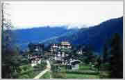
| URA Altitude: 3,100m / 10,170ft. The easternmost valley, Ura, is also the highest in Bumthang. Wide open spaces characterizes the valley that sits in the shadow of the Thrumsing La pass, separating the East from the West of the kingdom. Ura village and its new monastery are a charming stop before the climb to the east. Cobbled streets and a medieval feel give Ura an unusual yet very attractive atmosphere. The old women of Ura still wear sheepskin shawls on their backs which double as a blanket and cushion. |
|
EASTERN
BHUTAN This region comprises Mongar, Lhuentse, Trashigang and Trashi Yangste. Passes crossed are Rodang La and Narphung La both at much lower altitudes than passes in Western and Central. The forests dissipate and the altitude is lower. The warmer climate is suitable for growing corn, rice, wheat, potatoes and surprisingly lemon grass. Eastern Bhutan is known for its stunning hand-loomed textiles and the weavers are all masters of the "supplementary weft-weave" technique. Eastern Bhutan is the least travelled area of the country. Below are described the main areas of Eastern Bhutan. |
|
MONGAR |
 |
TRASHIGANG Altitude: 3,773m / 12,375ft. Trashigang is the eastern-most point on the highway. Eastern residents use Trashigang to trade and the town itself is usually a hive of activity, especially around the bus station where buses are frequently leaving for Thimphu and Paro in the west and Samdrup Jongkhar and India, only a few hours to the southeast. A short distance is Radhi considered one of Bhutan's most renowned weaver villages. Trashigang is also a melting pot of hill tribe people who come to the town to trade. The villagers of the remote Merak and Sakteng areas come to Trashigang to trade yak's butter for the provisions that they need in the mountains. Merak and Sakteng are located about 50 miles east of Trashigang close to the border with India's Arunachal Pradesh. |
|
Trashigang Dzong sits on a jagged piece of land jutting out from the town and is the first landmark that can be seen from the road winding up to Trashigang. The Dzong was built in 1659 and commands a spectacular view over the valley for which it is the administrative center. The Dzong is significant for the fact that it only has one courtyard. |
|
| TRASHI
YANGSTE Altitude: 1,850m / 6,070ft. On the drive to Trashi Yangtse you pass the small town of Duxsum located on the Drangme Chhu and its tributary. It is a few kilometers past Gom Kora. A large boulder sits in the garden of Gom Kora (Gomphu Kora) Temple and it is said that if anyone can climb below the rock and emerge from its summit, he will be forgiven of his sins. Duxsum is a small weaver's town where you can find a fair amount of weavers producing some very nice work. The landmark of the town is a original iron chain suspension bridge built by Thangtong Gyalpo or Lama Hazampa (Lama Iron-bridge) in the 1600's. Duxsum is the main supply town for all the high mountain villages that surround it. Trashi Yangtse is a small town and a lovely place from where the visitor can launch a hike into the surrounding countryside. Chorten Kora is one of the only two such stupas in Bhutan with styles similar to those found in Nepal and is host to a great festival every March which attracts all of eastern Bhutan's residents. The Chorten is entirely whitewashed and ideally situated next to a running brook. Trashi Yangste is also famous for its hand made wooden bowls and cups used all over the country. The finest are made from rhododendron burl. |
 |
SAMDRUP
JONGKHAR The road from Trashigang to Samdrup Jongkhar was completed in the early 1960s and enables the eastern parts of the kingdom to access and benefit from trade with the south as well as across the border into India. It is possible to drive from Samdrup Jongkhar to Phuentsholing, the eastern border town, via Assam and West Bengal of India. |
| From Trashigang the road descends through thick jungle before arriving at the border town of Samdrup Jongkhar. The town is no more than a frontier post with a couple of hotels and restaurants. Visitors can exit Bhutan from Samdrup Jongkhar, instead to driving back all the way back to Paro or Phuentsholing. Guwahati airport in India is located about 100 km from the border and from there there are daily flights to Calcutta and Delhi. | |